Read Elvis ASC File
This option will read an Elvis ASC file of points and insert them into the job.
An ASC file is a grid mesh file of XYZ points.
The file actually contains just some admin data and all the Z values.
The XY values are implied by the structure of the grid.
The admin data contains the number of rows, the number of columns, the grid cell size
and the grid lower left co-ordinates.
On each following line is one row of Z values.
ncols         2205
nrows         3780
xllcorner     151.44156
yllcorner     -30.27588
cellsize      0.00024
NODATA_value  -9999
-9999 -9999 797.4888 799.2144 800.212 800.6909 800.8506 800.9185
Geographic Data Format
In this file, each line contains 2205 Z values on each row of the grid.
The grid consists of 3780 rows of data.
The co-ordinates of the lower left corner of the grid are shown in longitude and
latitude values in decimal degrees.
The grid cell size is given in decimal degrees. (0.00024 degrees = 29 metres)
Where a grid cell has no Z value, the value -9999 is used.
Note that the lines in this file can be very long, they must be long enough to hold
one complete row of data which in this case is 2205 Z values, approx 16,000 characters in length.
Easting, Northing Data Format
It will contain the ncols and nrows as above.
The xllcorner, yll corner and cellsize are in metres.
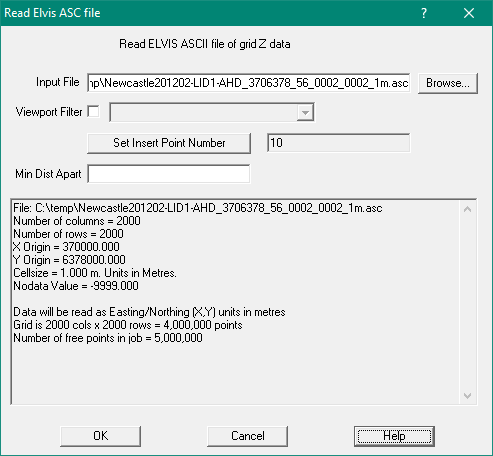
Input ASC File
Enter the name of the raw ASC data file to be read into the job.
This file will contain X,Y,Z points data as described above.
Viewport Filter
When selected, only points within the viewport will be inserted into the job.
This option allows you to read VERY large ASCII data files and only read in the
part of the file that is of interest.
Set Insert Point Number
Allows you to set the first point number for the new points, using the Point Settings Menu.
Min Dist Apart
Allows you to reduce the number ofpoints read in
If left blank or 0.0, all points will be read in.
If the grid points are 1m apart and min_dist is 1.5, every second point will be read in
and every second row will be read in.
Set it to 9.5 to read every 10th point (for a 1m grid).
Important - Projection
You must set the job projection before using this option.
Usually the data will come with an explanatory html file showing the projection used
You can also get the projection from the .prj file
ELVIS Elevation Information System
ELVIS is a repository of gridded height data derived from LIDAR surveys.
To access look up “ELVIS-Elevation-Foundation Data” or click on
elevation.fsdf.org.au
You can download LIDAR datasets from the Elvis web site
Instructions are provided on line as follows:
Elevation - Foundation Spatial Data
Here you can download point cloud and elevation datasets sourced from jurisdictions.
Data can be downloaded at no charge
How to use
- Pan and zoom the map to your area of interest,
- Click on the "Select an area..." button to enable drawing,
- Click on the map, holding the button down,
- Drag to a diagonal corner (not too big, there is a limit of roughly 2 square degrees or 200 square km))
- On release we will check for data within or very near your area of interest
- If the list is large you can filter it
- Check against any file you would like to download. To reiterate, these files can be huge so take note of the file size before downloading
- Review your selected datasets and submit.
- An email will be sent to you with a link to all your data, zipped into a single file.
- These files can be huge so take note of the file size before submitting or downloading
Hints
- Hovering over many items will give you further information about the purpose of the item
- Drawing a polyline allows you to measure distance along the polyline.
- On completion on drawing a line the elevation along that line is plotted.
- While the tool to draw your area of interest is enabled it is easiest to pan the map using the arrow keys.
- There are many areas where there is no data though the coverage is improving all the time.
The downloaded packet of data comes as a zip file which contains three files:
- A metadata file which has a .html extension
e.g. Dungog201601-LIDI-AHD_4046420_56_0002_0002_1m_Metadata.html
- An ESRI projection file which has a .prj extension.
e.g. Dungog201601-LIDI-AHD_4046420_56_0002_0002_1m_.prj
- The grid file which has a .acs extension.
e.g. Dungog201601-LIDI-AHD_4046420_56_0002_0002_1m_.asc
Grid files can be in either a geographic grid (latitude/longitude) or rectangular (MGA eastings/northings) format.
The geographic grids have a grid spacing defined in seconds of arc – typically: one second spacing, five second spacing etc
At the Latitude of Sydney, one second is about 27 metres on the ground.
The rectangular grids have a grid spacing in metres – typically one metre, five metres etc.